Following on from last month’s analysis of the 1893 map, this month looks at the remaining two quadrants of the map.
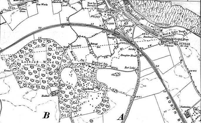
Starting at the top right of the map, under the Municipal and Police Burgh Boundary, is Kirkhill House, described in 1854 as “About 3/8 Mile East from Dunbar Station A commodious dwelling house with Offices and a few acres of ground attached the residence and property of Dr [Doctor] Kellie”. The owner is later referred to as Dr Kelly, an owner of property in the High Street and West. See here for 20 references to Dr Kellie/Kelly and Kirkhill. Newhouse and Beachmont are listed and have streets named after them in the houses known as the Walker Homes.
Above Beachmont, you can see Seafield Cottage now called Seafield House in East Links Road and in 1854, this was referred to as ” [Situation] About 15 chains East of the Ph [Parish] Church. A neat dwelling house with Offices and garden attached occupied by Alexander Steadman and the property of R.C. Dunbar”. A chain was 22 yards when it was used as a measurement. R.C. Dunbar was Robert Corson. Going towards the Parish Church, a Police Station is noted and as you enter the High Street, the Free Church Manse on Church Street is shown, as is the Freemasons’ Lodge which opened in 1758.
Also at 34 High Street the New Inn Barracks are listed, and they stood on the site where the former St Andrews retirement home. This property is described here as “Commissioned by Earl of Lauderdale alledgedly as competition to the St George Hotel. Called the ‘New Inn’ then: still referred to as such today. Used as barracks in 19th century”. In the same document “Alexander Ponton, 1788-91. 3-storey, L-plan house with basement to rear wing” and a full description of the house’s architecture.
Going west from the barracks, you can see Edenholme which later became the Eden Hotel. The house was the subject of a DDHS talk by Dr Pat Simpson and this will be featured in the November 2019 Resources section. Further west, the gas works are noted and this Canmore site states “Dunbar Gasworks was probably founded about 1826 and substantially expanded in the 1880s; it is an early example of a dedicated municipal gas supply”. The gas works closed in the 1960s and many local people remember going to the gas works to get cinders for their house’s coal fire. The cinders came red hot out of the furnace and were put under a huge spray, resulting in a wonderful hiss and a cloud of steam. Gallows Green – now called Gala Green – is recorded in 1854 as ” About 10 Chains South from KnocKenhair. A narrow piece of land on the south side of the road leading from Dunbar to Edinburgh, in former times it is said Criminals were executed here”. No supporting evidence is given to verify the link between the area and hangings.
In the middle of the map, Lochend Wood is prominently shown and you can read the history of the wood, including an 1854 map, here. “Within the grounds of Lochend House are the fragments of a two-storeyed 17th century mansion” and you can read more about the house and its structure here.

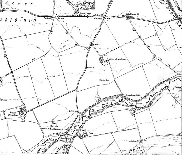
The final quadrant of the map is shown above. Near the top of the map, to the east of South Lodge is Cleikminin, described in 1854 as “A Toll Bar at a junction of roads situated about half a mile south of the town of Dunbar” with a further note stating that “Cleikimin is a name usually applied to a public house by way sobriquet conveying the idea of ensuring entrapping customers & is applied to low public houses”. The site advises looking up cleik and it means a hook or walking stick, so Cleikminin presumably means “hook them in”. Further south, Easter Broomhouse is described in 1854 as “A farm house with extensive offices – a Thrashing Mill worked by steam – a garden and a large arable farm attached – and in the possession of John Dodgson – farmer”. Also noted – and on the mapto the south – is Broomhouse Mill – again under the name of Dodgson – “A corn mill with a dwelling house and some Cottages attached, erected by the proprietor for the convenience of the farmers residing in the neighbourhood”. Easter Broomhouse is now a group of cottages up from the Spott Roundabout. To the southwest is Wester Broomhouse, in 1854 “A farm house with offices, a thrashing Mill worked by steam, some Cottages, and a large farm attached; belonging to Mrs Ferguson of Beil”, with Mr Nelson, Farmer noted and who may have run the farm. He is mentioned in the description of Old Broomhouse – “Two or three cottages of a mean description, occupied by farm labourers in the employment of Mr Nelson, Broomhouse. It was formerly a farm house”. We can assume that of mean description means that the cottages were in a poor state of repair. It should also be noted that in relation to Mrs Ferguson, Beil was used as well as Biel – used today – as name for that area.
Finally, to the west of Broomhouse Mill is the site of what is often called the First Battle of Dunbar, where the Scots army was routed. For a full analysis of the battle, including maps, see here.
You must be logged in to post a comment.