The map this month is from 1893 and is an extract from a 6 inch map of Haddingtonshire as East Lothian was known then. The first two quadrants of the map are discussed below.
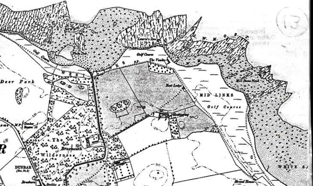
The first part of the map to be highlighted takes in Broxmouth Estate, including The Wilderness , Dunbar Golf Course and the shoreline around the course. At the top right of the map, you will see the letters L.W.M.O.S.T. This stands for Low Water Mark of Ordinary Spring Tides. Below that is the High Water Mark. To the left of this can be seen Lawrie’s Den a rock stack off the golf course – see photo here but there is no explanation of the name. To the left of the Den, you can see Fluke Dub, described here as “A Small hollow bed of Sand Situated between high and low water mark and near the mouth of Brox Burn. Fish called flounders commonly called flukes are caught here hence the name”. To the right of Lawrie’s Den, Mill Stone Neuk is named and this was, according to the Canmore site, “A site where millstones have been quarried. Circular depressions may be visible, along with unfinished or broken millstones”.
On the golf course, you can see West Links and Mid Links as if they are two separate courses. to the left of Mid Links, is Sloebigging described here as “A Farm Steading in the policy of Broxmouth. It consists of a dwelling house two Storeys high outhouses And cottages the dwellings are Occupied by the Servants of the establishment of the Countess Dowager of Roxburgh and the land about 180 Acres is farmed by the Owner”. Under Authorities for Spelling are listed “Mr Denholm Broxmouth Dunbar, James Bishop Broxburn Dunbar, G Rennie Oxwell Mains Dunbar” but it is not clear who the owner might be. There is no information on the origin of the name. On the same site, The Vaults – see below Lawrie’s Den – is described as “A Row of three Cottages on the links at the Sea Shore about 1/2 Mile NE [North East] of Broxmouth House And derives its name from having been used as a Corn Store when the rents were taken by the Fuars; the whole basement rooms were arched or vaulted (hence the name) It has recently be converted into three commodious cottages, Occupied by Fisherman, And the property of the Duke of Roxburgh”. The authorities here are listed as “Mr Denholm Broxmouth Dunbar, G Rennie Oxwell Mains Dunbar”.
At the bottom right of the map, Strand House is named. This Canmore site which relates to the finding of burial cists, refers to “Trial trenching of the area of the demolished 19th-century Strand House and sheepfolds failed to unearth significant archaeological features or finds”.
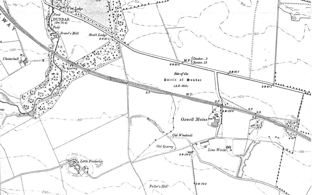
The second section shows the land to the south east of the town. At the top left, you will see West Lodge and South Lodge below. Historic Environment Scotland comment “The house [Broxmouth House) is now approached from the West Lodge, a single-storey 19th century building, as shown on the 1799 county map (Forrest, 1799). The entrance at the South Lodge is in use, and leads along the Green Avenue (1876, OS 25″) with a curving driveway flanking it to the east which was probably inserted in the 19th century”. The Forrest 1799 map can be viewed here. Below South Lodge, Broxmouth Ward is prominently shown. This Canmore site refers to an archaeological find “An early Bronze Age Beaker, Type F from Broxmouth Waird, Oxwell Mains, Dunbar, is preserved in the National Museum of Antiquities of Scotland (NMAS), Edinburgh, No. EG44”, with Waird replacing Ward. For a detailed definition of Ward/Waird in this context, see here.
Further south is Little Pinkerton which is still a farm with cottages and a big house today. There may or may not have been a chapel at Pinkerton – see here. To the right is Fuller’s Hill referred to here as “[Situation] About 1 Mile W by S [West by South] from East Barns A hill of slight elevation on the farm of Meikle Pinkerton. Its surface consists of arable land. On it is a Trigl [Trigonometrical] Station called by Trigl [Trigonometrical] Party after the farm”. The site of the Battle of Dunbar 1650 is highlighted and above that there is a milestone (M.P.) showing Dunbar 2 miles away and Renton 12 miles away. Renton was obviously an important place in 1893 and you can read about its history here.
Oxwell Mains, now the site of the cement works, was a farm at that time and in 1854, this was described as
“[Situation] About 3/4 Mile W by N [West by North] from East Barns. A farm house and out houses in good repair having a farm of about 400 acres of land attached. The property of the Duke of Roxburgh. A little to the S.W. [South West] of this farm house is the ruin of an old windmill”.
The Old Windmill can be seen on the map to the southwest of the farm.
The nearby lime works were described in 1854 as “Large lime works having kilns attached on the farm of Oxwell Mains, the property of the Duke of Roxburgh”. To the southwest of the lime works, the Old Quarry is noted on the map and in 1854, this was recorded as Burlage Quarry “[Situation] About 1 Mile W by N [West by North] from East Barns. A large limestone quarry on the farm of Meikle Pinkerton. It is now but little wrought, and is nearly filled with water”. The term little wrought would not be used today. The 1854 references come from here. Further south, Fuller’s Hill is noted but no origin of the name could be found. It is still on modern maps, such as this one.
Overall, one of the key facts to be gathered from the analysis of this map is just how dominant the Duke of Roxburgh was as a landowner in this area.
You must be logged in to post a comment.