The 2nd part of Jim Herring’s analysis of the 1899 Map of Dunbar is now complete. You can watch a video of this virtual talk below.
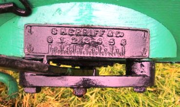
The talk features the Rifle Range and Targets used by volunteer soldiers such as the Haddington Artillery Volunteers who were based in Dunbar at Volunteers Hall, now the British legion. There were also local shooting groups who formed a league and included masons and shepherds. A number of burial cists were found at the edge of Belhaven Beach and are noted on the map. These originated in the 5th to 7th century and were made of slabs of stone from the nearby rocks. Wilkie Haugh, the area between the end of Winterfield Promendade and St Margarets, home of Winterfield Golf Club is also discussed. The first part of the talk ends with an outline of Winterfield Mains farm and the Belhaven chalets sit on what was part of the farm. The second half of the talk focuses on the Implement Works in West Barns and this was run by Sherriff and Co which later became Thomas Sherriff and Co. The photo below shows a Sherriff plate on a piece of agricultural machinery.
The large Seafield Brick and Tile Works is also analysed. An advert for the brick works, greatly expanded by William Brodie is shown below. Working conditions on farms and brick works in the 19th century were of often very poor and the talk gives a wider picture of working conditions at this time, which contrasted with the large houses and affluence of farmers and factory owners.


You must be logged in to post a comment.